January 21, 2017
By Dorothy Rice Bennett
“Have you hiked the Cape Flattery Trail yet?” That’s one of the first questions you hear when you visit or move to the Olympic Peninsula.
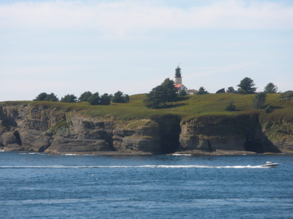
When I relocated to Sequim, it took me a little while to get my head around the question. Cape Flattery is the name of a lighthouse and the location of a piece of land on the Makah Indian Reservation. This chunk of land marks the most west/northwest point of the Continental United States. The Cape Flattery Lighthouse, itself, is actually located on Tatoosh Island, off the coast but visible, as long as the weather is clear, from the western end of the Cape Flattery Trail.
Eventually, I got with the program and traveled with my partner, Connie Jenkins, to Neah Bay to walk this famous trail. It begins from a parking lot at the end of a nice loop road coming from Neah Bay, which is home to the Makah Nation. Neah Bay has long been a native fishing village that also houses the Makah Cultural and Research Center—including a beautiful museum that presents the history and geography of the area and the Makah people.
Getting there
From Sequim, Cape Flattery is about two hours each way, so it is a full day’s trip to do the drive and then walk the three-fourths mile trail downhill to the lighthouse lookout and back up the trail to the parking lot. The trip starts by going west on Highway 101 and through Port Angeles. Beyond PA, there are two choices: shortly turn right onto highway 112, go through the community of Joyce, and wind westward 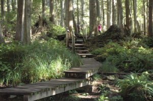 toward Clallam Bay, Sekiu, and then Neah Bay. Or, you can stay on the 101 past Lake Crescent and then turn north on highway 113 and follow it until that road meets the 112 and then continue west to Neah Bay. No matter how you do it, it is a fairly long drive but has scenic moments. From Clallam Bay westward, you are often driving along the Straits of Juan de Fuca, always beautiful no matter the weather.
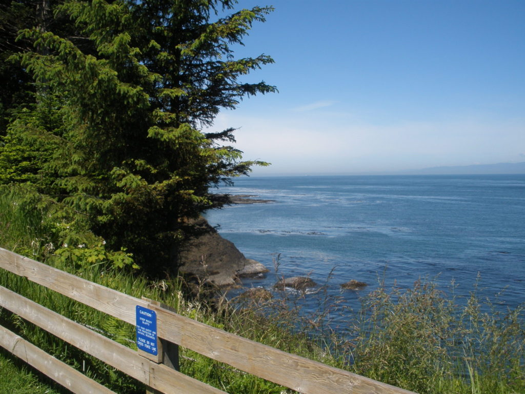
Pass through Neah Bay on the main street and then follow the signs to the Cape Flattery Trail. You will drive on Cape Flattery Road and Cape Loop Road for a few miles. Then, in the trailhead parking lot, there are rest rooms. Use them. Take bottles of water and energy snacks. The trail is considered a moderately difficult walking trail. But sometimes you are on the ground, sometimes you may be in mud, sometimes you are walking on slices of trees trunks, sometimes you are walking on wooden planks, and sometimes you are walking over and around gnarled tree roots. Sometimes you are at ground level, and sometimes you are two feet above it. Sometimes you have railings, and at times there are none. So the trail can be challenging.
Magical forest
Cape Flattery is a rain forest and incredibly beautiful. My partner and I have gone several times and I always feel as if I am in a Disney movie. The light filters through the trees in magical ways, and the forest growth is whimsical. The many shades o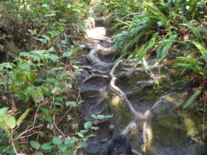 f green foliage are luminous. There are hollowed out trunks that you can step into. There is much to photograph. I’ll repeat: There is much to
photograph. And if you have a walking stick, you may need it to climb back up the hill. There is a rise of only two-hundred feet over the three-quarters of a mile, but it will seem like more than that at the time.
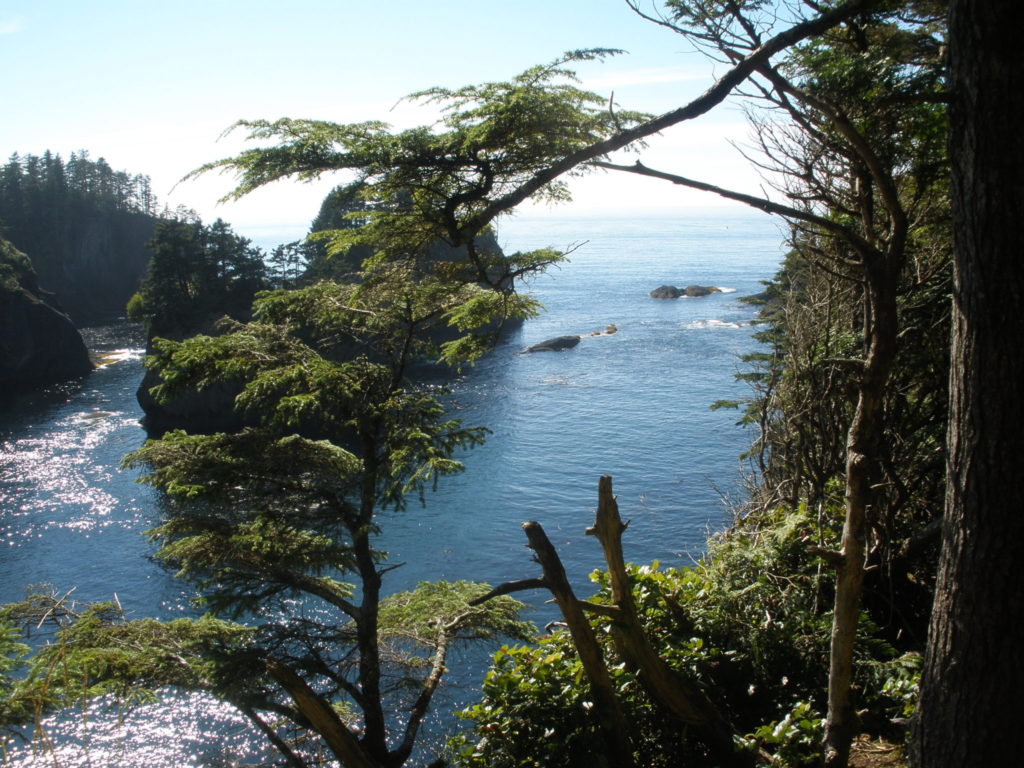
When you get near the bottom of the trail, there are 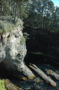 places to your left and right with lookouts. These have benches, railings, and breathtaking views of caves, rugged bluffs, crashing waves, shore birds in their habitat, turquoise waters, and monoliths off the shoreline.
At the very end of the trail, there is a wooden structure with some large steps—requiring strength and agility to climb—that contains a lookout platform to observe the lighthouse on Tatoosh Island. This is also top picture-taking time. A narrow path goes around this structure, so that you can get in front of it—without having to climb—and also take pictures of the lighthouse. (As an aside, Connie and I both got some great shots on this walk, some of which you can see in this blog.)
Catch your breath!
Pause a few minutes before starting back. If you are a bit older, as I am, it will take all you’ve got to get back up that trail to your vehicle. Take your time, and you can do it. And be prepared for many nice people, speaking seemingly every language of the world. And lots of leashed dogs, big and small. Everyone is welcome here, and everyone comes.
When you return to Neah Bay, if you have time, visit the museum. It is amazing. I passed it more than once before I finally toured it, and now I’ll never pass the museum by again. Admission is reasonable, and there is a nice gift shop and clean restrooms. Before you leave town, gas up your car for your return trip to Sequim. For dinner, I recommend stopping in Joyce. My personal choice eatery is the Blackberry Café, where they put blackberries in just about everything. This place is a traveler’s favorite.
The Olympic Peninsula offers many outdoor things to do. Cape Flattery Trail ranks highly as a must for anyone in reasonably good hiking/walking condition. There isn’t a more beautiful spot around, and that’s saying a lot, because this Peninsula is filled with natural beauty.
For some local information before you go, try the following and have fun!
http://makah.com/activities/cape-flattery-trail/
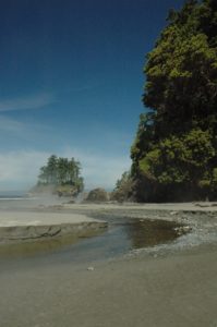 into the Straits. The day we visited, there was a mist hanging over the creek water. It was beautiful and eerie, and we have never seen that mist again during our many visits to the area. Our cameras came out, and we took a lot of pictures of the creek, the bluff to our right (which is part of the main park above), the monolith ahead and to our left (covered with trees on the top) and the rocky coastline that could be walked by the sure of foot.